
EarthDefine Clutter3D
Telecom's most precise RF clutter dataset. Signal-aware classes, per-pixel LiDAR heights, nationwide at 1m resolution.
EarthDefine Clutter3D is a 20-class RF clutter dataset covering the continental US at 1-meter resolution. Five layers deliver consistent fidelity everywhere, with no gaps, whether in rural Wyoming or downtown Chicago. Every pixel carries an exact height value derived directly from LiDAR, so you plan from measurements, not estimates. It imports directly into Atoll, Infovista Planet, Mentum, and any platform that accepts standard raster inputs.
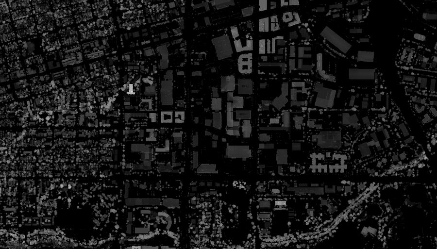
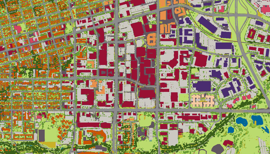
Toggle the layers below to explore all five datasets included in every order: imagery, DEM/AMSL, nDSM/AGL, clutter classes, and building vectors.
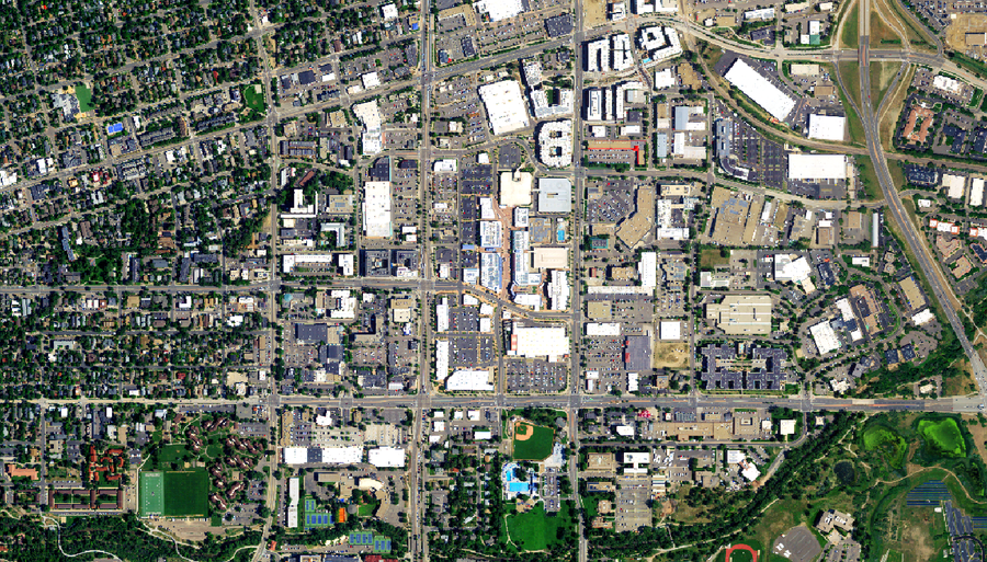


Bare Earth (DEM). The ground itself, with buildings and vegetation stripped away. It gives you terrain elevation Above Mean Sea Level (AMSL), the baseline for path profiles and the reference every obstacle is measured against.
Heights (Normalized-DSM or nDSM). How tall every above-ground feature stands, buildings and canopy alike, measured directly from LiDAR. These are feature heights Above Ground Level (AGL), so adding nDSM to the bare-earth DEM gives you the absolute elevation of any obstruction between transmitter and receiver.
Clutter Classes. Twenty land-cover types, from dense urban to forest to water, mapped at 1-meter resolution. This is the layer your RF model reads to assign loss as a signal crosses the terrain. More on this below.
Building Outlines. Vector footprints for every structure in the scene. Use them to identify which obstructions are buildings, isolate the built environment, or tie clutter to specific structures.
Most clutter datasets were designed for land use monitoring, not RF engineering. Our 20-class schema is built differently: every class reflects RF propagation behavior, every pixel carries a LiDAR-measured height value, and the schema spans the full range of environments across the continental US, from open rural terrain to dense urban cores. Hover any row to preview it.

Hover any row below to preview
| Clutter Class | Description |
|---|---|
| 10. Water | Sea, ocean, river, pond, lake (excludes swimming pools) |
| 20. Bare Earth | Soil, sand, rock, clearings |
| 30. Vegetation 4 classes | Trees, shrubs, ground cover, crops |
| 31. Ground-level Vegetation | Fields, grass, ground cover, low crops, turf |
| 32. Low Vegetation | Shrubs and herbaceous |
| 33. Tree, Low Density | Part of small clump |
| 34. Tree, High Density | Part of large contiguous canopy |
| 40. Residential Buildings 3 classes | Single/multi-family housing at varying densities |
| 41. Residential, Low Density | Isolated structures (e.g., rural residential) |
| 42. Residential, Med. Density | Buildings forming small clumps |
| 43. Residential, High Density | Buildings forming large contiguous clumps |
| 50. Commercial Buildings 3 classes | Office, mall, institution, community facility |
| 51. Commercial, Low Density | Isolated buildings not part of clump, e.g., rural |
| 52. Commercial, Med. Density | Buildings part of small clump, e.g., suburban corridor |
| 53. Commercial, High Density | Buildings part of large clump, e.g., CBD |
| 60. Industrial Buildings 3 classes | Factory, plant, heavy goods storage |
| 61. Industrial, Low Density | Isolated industrial structures |
| 62. Industrial, Med. Density | Buildings part of small clump |
| 63. Industrial, High Density | Buildings part of large clump |
| 70. Transport & Impervious 5 classes | Paved surfaces and transportation corridors |
| 71. Parking | Surface parking lots and structures |
| 72. Roads | All paved road surfaces |
| 73. Railways | Rail corridors and associated structures |
| 74. Airports | Runways, taxiways, and airport grounds |
| 75. Other Impervious | Paved or hardened surfaces not classified elsewhere |
At 10m resolution, a tree and the building behind it can occupy the same pixel, and height values are estimated rather than measured. Your propagation model is only as accurate as your clutter data. Here is how a typical 10m product compares to EarthDefine's 1m product for the same area.


At 10m resolution, a tree canopy and the building behind it collapse into a single pixel with an estimated height that reflects neither. In suburban and exurban terrain with moderate-to-dense tree cover, coarse clutter typically introduces 2-4 dB of error in Reference Signal Received Power (RSRP) prediction.
Small improvements in clutter accuracy can materially change RF outcomes. A 2-4 dB error is often the difference between predicted coverage and real-world performance. EarthDefine's 1m clutter resolves obstructions individually: trees, buildings, and ground features are individuated rather than averaged, and each class carries a LiDAR-measured height.
EarthDefine Clutter3D is drop-in compatible with the tools your team already uses for RF propagation modeling: no reformatting or reprojection. Every delivery includes LiDAR-derived heights, nDSM/AGL, DEM/AMSL, building outlines, and high-resolution imagery in a single ready-to-use package.
Also loads directly into Esri ArcGIS, QGIS, and any GDAL-supported platform. GDAL import workflows available on request.
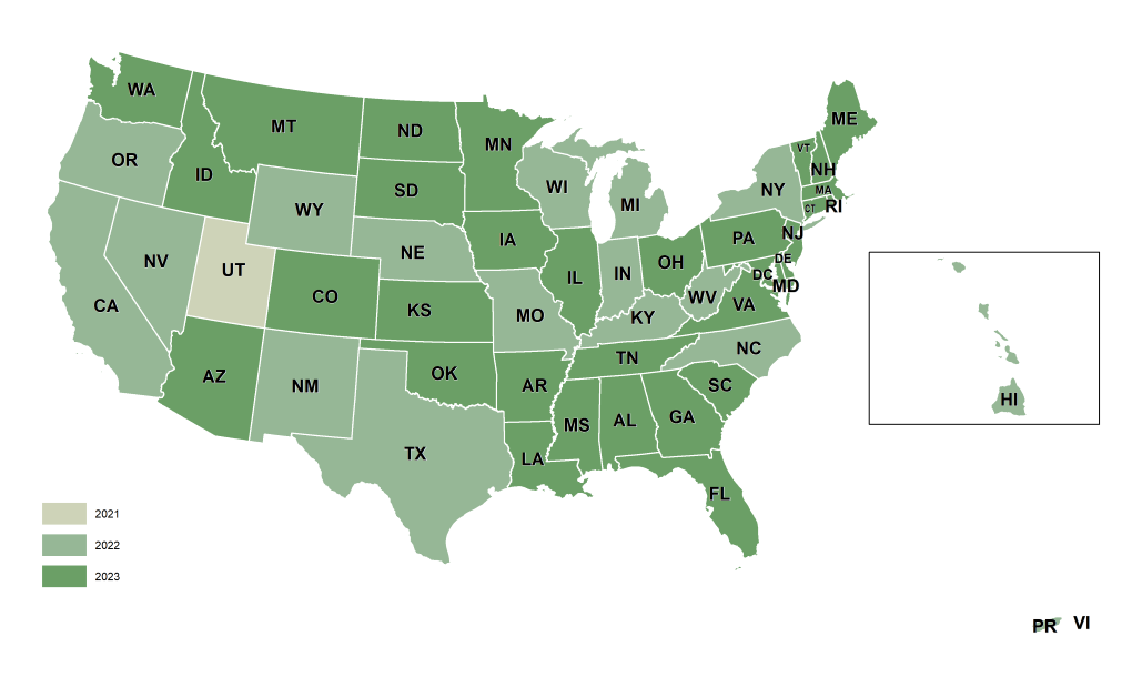
EarthDefine Clutter3D is available as a seamless, ready-to-deliver dataset for any area within the United States: no stitching, no gaps. 3,125,942 square miles covering the contiguous US, Puerto Rico, and the US Virgin Islands.
NAIP acquires roughly half the continental US every year. As each new cycle completes, EarthDefine produces updated clutter data for affected areas, so your models always reflect the latest available imagery. Every dataset includes source imagery metadata so predictions stay reproducible and defensible.
A 20-class RF clutter dataset at 1m resolution with per-pixel LiDAR heights, plus nDSM/AGL, DEM/AMSL, building vectors and source imagery, with nationwide US coverage.
It is up to 900x finer than legacy 30m clutter, with greater than 95% classification accuracy and true LiDAR-derived heights instead of interpolated estimates.
It is purpose-built for RF propagation modelling and 5G network planning in tools such as Atoll, Planet and EDX.
Coarse 10m clutter can introduce 2-4 dB of RSRP (Reference Signal Received Power) error; because each 1 dB of modelling improvement can yield meaningful RAN (Radio Access Network) capacity gains, higher-resolution clutter directly improves network planning.
Yes. Download a free Clutter3D sample to evaluate it in your planning tool.
Talk to our team about a Clutter3D delivery for your markets, or download a free sample to load into your RF planning tool.

